
Iceland is abundant with natural phenomena and to protect some of this nature, three national parks have been established in recent decades: Thingvellir National Park, Snaefellsjokull National Park, and Vatnajokull National Park.
The Vatnajökull National Park:
- covers approximately 13% of Iceland's land mass, making it not only the largest of the three Icelandic national parks but also one of the largest national parks in Europe.
- covers approximately 13.920 km²
- aims to protect a variety of agricultural, geological, and botanical highlights.
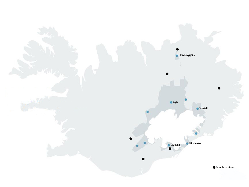
The park was established in 2008 and includes the areas of the Vatnajokull glacier and the two pre-existing national parks Skaftafell and Jokulsargljufur as well as the surrounding areas. In 2019, the national park was declared a UNESCO World Heritage Site. The majority of the national park is concealed under the thick ice cover of the glacier of the same name. Nonetheless, the landscape is unique and diverse due to the interplay of volcanoes and glaciers. It showcases the effects that the forces of rivers, glacial ice, and volcanic and geothermal activity can have.
High mountain ridges rise to the south of the glacier, interrupted only by imposing outlet glaciers that extend into the lowlands. Iceland's highest peak, Hvannadalshnukur, can also be found here. At a height of 2.110 meters, the volcano towers over the entire region. Surrounded by snow and ice is the green oasis of Skaftafell and the nearby black sand, which consists of ash from the Grimsvotn volcano that is carried to the coast by the glaciers. The country's largest glacial lakes are also located in the southern national park area. Jokulsarlon and Fjallsarlon can be reached via the ring road.
In the north of the national park are the legendary Asbyrgi Gorge and Dettifoss, one of the most powerful waterfalls in Europe. There is a hiking trail through the gorge that takes you from the waterfall to Asbyrgi. Another natural phenomenon is the Jokulsargljufur region, known for its stark contrasts. The large area of Holmatungur is characterized by lush vegetation and crystal-clear rivers running through the landscape. The cliffs and scree slopes provide shelter for both fauna and flora.
The east of the national park includes parts of the central highlands. The Snaefell wilderness area is home to many reindeer and the breathtaking Lonsoraefi landscape features colorful geological formations on the inner sides of the extinct central volcano Snaefell.
The lowlands of the western area of the national park are covered in moss-covered lava fields. Much of the lava comes from the Eldgja fissure, which was formed in 930 by an eruption of the Katla volcano system. Deep in the highlands are numerous linear mountains, or more precisely, hyaloclastite ridges (a type of rock found only in Iceland), which influence the direction of the glacial rivers.
If you want to know more about the sights, tours, and general information, you can do so at one of the visitor centers. The largest center is located in Skaftafell. The Skaftafellsstofa Visitor Center is open all year round and rangers and staff at the center provide information about the national park. This includes hiking trails, nature, and accommodation. There is also a small souvenir store with handmade items from the region. The other centers are located in Skaftafell and Snaefellsstofa.
A map shows which hikes can be undertaken in the national park. There is also a wide range of excursions to the national park, such as an ice cave tour or a hike across the Vatnajokull glacier.
Location & Approach
Vatnajokull National Park begins in the east of the country near Hofn and runs along the southeast coast, past Skaftafell to the height of Krikjunaejarklaustur. To the west, the border runs along the Sprendisandur border and ends in the northern part of the Odadahraun desert. In addition, the spatially separated area of the former Jokulsargljufur National Park in the north of Iceland is part of Vatnajokull National Park.
Coming from Reykjavik, road 1 (ring road) leads past the south side of the national park. If you want to visit the glacier, you need a local guide and it is best to book a tour.
Historical significance
There are numerous cultural remains from ancient times in various areas of the national park. These sites provide insight into the settlement and cultivation of the regions, as well as the natural and supernatural forces that people had to contend with.
South of the glacier, the area is scattered with the ruins of old farming and fishing operations. Old hiking trails through difficult terrain, over rushing rivers, and icy glaciers connect the settlements. Over time, the local people have adapted to the difficult living conditions caused by the harsh nature and the constantly changing glaciers.
In the highlands to the west, north, and east of the glacier, there were travel routes in past centuries, the remains of which can still be found today in the form of cairns, ropeways, fords, and shepherds' huts. The region also contains abandoned farms, old horse trails, and ancient cultural monuments that bear witness to human habitation. A large part of the area was once pastureland used for sheep farming.
Geological significance
The national park could be described as a geological national park due to its unique geological history. The park offers a rare opportunity to observe the battle between plate boundaries, mantle plumes, and plateau glaciers, which results in a constantly changing environment.
It is home to many of the country's most active and powerful central volcanoes, as well as some extinct volcanoes. Seven of the ten central volcanoes are hidden under the ice cap of the Vatnajokull glacier. However, this can change over time, as volcanic activity and the extensive geothermal areas are permanently melting the glacier ice. This melting can lead to glacial floods and eruptions, rupturing the ice cap and even spreading volcanic ash. These forces of nature ensure that the landscape around the glacier is constantly changing.
Flora & Fauna
The national park area boasts a diverse range of geology and climate, resulting in a rich variety of flora and fauna. From barren glacial plains to lush birch forests, the vegetation encompasses highland vegetation, wetlands, green oases on the edge of lava fields, and swathes of moss and heathland. The Icelandic highlands are notably the driest area in the country, while the surrounding regions to the southwest, south, and east are the wettest on the entire island. In the north, sparsely vegetated lava areas dominate, with lichens only growing on the lava fields of Krepputunga and Odadahraun. In the southern part of the national park, mosses predominate, accounting for up to 90% of the total vegetation in some areas. Contrasting with the barren landscape, green and densely overgrown oases at Herdubreidarlindir, Jokulsargljufur, and in certain places under the southern slopes of Vatnajokull are home to taller plants, shrubs, and flowers alongside the moss. South of the glacier, especially on Skaftfell, tall birch forests can also be found.
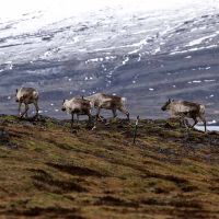 The region's wildlife reflects a great diversity. The Snaefellsoraefi area on the north-eastern edge of the park is home to a large number of Ruddy Shelduck, which lay their eggs and plumage there. There are also around 2000 reindeer that roam freely in the summer and spend the winter in the valley regions on the south-eastern edge. The area south of the glacier is home to a wide variety of bird species. The rivers and lakes of the national park are populated by native char and trout species. Seals can also be spotted in the region around the Jokulsarlon glacier lagoon, and, with a bit of luck, you may come across an Icelandic fox.
Sights around the National Park.
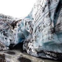 Vatnajökull glacier
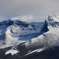
At 8.100 square kilometers, the Vatnajokull glacier covers around 8% of Iceland's land mass with a sheet of ice. This makes it the largest glacier not only in Iceland but also in the whole of Europe. Vatnajokull has over 30 outlet glaciers that flow out of the ice caps. The best-known outlet glaciers include Dyngjujokull in the north, Breidamerkurjokull in the south, and Sidujokull, Skaftarjokull, and Tungnaarjokull in the west.
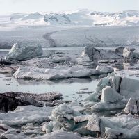 Jökulsárlón
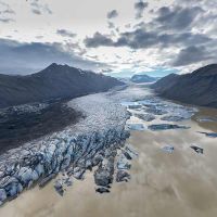
The Jokulsarlon and Fjallsarlon glacier lagoons are two of the most popular sights in Iceland for good reason. The combination of glacier proximity, unique nature, and tourism attracts many visitors to the coastline from Kviarmyrarkambur to Hofn every year. The lagoon is located on the Vatnajokull foothills of Breidamerkurjokull and is now Iceland's largest lake. The huge icebergs floating in the glacier lagoon, which repeatedly break off from the glacier, make the lagoon so special. A boat trip across the lagoon allows you to admire the glacial lake from many different angles and offers many great photo opportunities with crystal-clear or blue pieces of ice floating by. If you are lucky, you might spot seals relaxing or sunbathing on the floating ice floes.
Skaftafell
Skaftafell was a manor house and local meeting place in the Middle Ages. Parts of the area around Skaftafell were declared a national park in 1967 and integrated into the newly established national park in 2008. The many hiking trails through the area's extremely varied landscape make Skaftafell an excellent excursion destination. There are short and easy trails leading to the Svartifoss waterfall and Skaftafellsjokull glacier, as well as more challenging trails for experienced hikers heading further afield to places such as the Morsardalut valley or the country's highest peak, Hvannadalshnjukur. There are many unique outlet glaciers and rivers that characterize the area and the diverse vegetation with birch forests makes the area truly unique.
 Askja
Askja
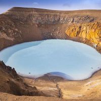
Askja is a volcano in the Icelandic highlands north of the Vatnajokull glacier. The caldera is best known for its dramatic eruptions. The last eruption took place in 1961, which did not have a major impact but showed that the volcano is still active. Askja is also home to Iceland's second-deepest lake, Oskjuvatn, with a maximum depth of 220 meter. The caldera is a well-known hiking destination with mountain huts for overnight stays, although these can only be used in summer. The moon-like landscape was also used as a training ground by the Apollo astronauts.
 Snaefell
The "Snow Mountain" is an ancient central volcano in the eastern highlands and, at 1.833 meters, it is the fourth-highest mountain in Iceland. The lush vegetation makes it an ideal home for numerous animal and plant species. Reindeer, in particular, can often be found here in the summer. The approximately 8 km hiking trail to the top of the mountain offers a fantastic view over East Iceland. Additionally, hikers can collect a stamp at the summit as a souvenir. Interestingly, the mountain was also used as a training ground by the Apollo astronauts.
Heinaberg
The glacier tongues Skalafellsjokull, Heinabergsjokull, Flaajokull, and Hoffellsjokull are the undisputed trademarks of the region. Large herds of reindeer can often be seen here between fall and spring. Many hiking trails in this area invite you to discover and explore.
Lakagigar
Lakagigar is a series of over 130 craters with a length of over 29 kilometers, which were formed during the Skaftareldar eruptions in 1783-1784. The eruptions were one of the country's worst natural disasters. It significantly affected the climate, the harvest, and thus the livelihood of the people. Nowadays, the craters are covered in moss and are a unique excursion destination.
Eldgjá & Langisjór
The volcanic fissure known as Eldgja stretches from Myrdalsjokull almost as far as Vatnajokull. It is approx. 8 kilometers long,600 meters wide, and 150 meters deep, and was formed in 939 during one of the biggest volcanic eruptions in Icelandic history.
 Dettifoss
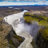
The Dettifoss waterfall translates as "the collapsing waterfall" and is one of the most powerful waterfalls in Europe. Every second, around 500m³ of water flows over the 100 m wide and 45 m high edge into the depths below. The waterfall is fed by the glacial river Jokulsa a Fjollum, which originates from the Vatnajokull glacier.
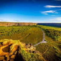 Asbyrgi
Asbyrgi Gorge is a fascinating horseshoe-shaped rock formation in Oxarfjordur, which according to legend was created by Odin's eight-legged horse Sleipnir, who touched the ground with one of his huge hooves while riding. Icelanders agree that this gorge is the capital of hidden creatures and that elves and trolls still live there today. There is also a small visitor center in the gorge where guests can learn about the area.
Many excursions to Vatnajokull National Park can be booked directly with us - feel free to contact us! You can find more inspiration for great excursions and your next round trip to Iceland in our travel overview.